Cathcart Park (2009 – present)
This project was started in 2009 to protect and improve approximately 1,000 metres of shoreline. The work is geared to replace a failing steel sheet pile wall with a revetment comprised of stepped armour stone and sloped rip rap. The first phase of construction started in 2011. As of 2013, 300 metres of shoreline have been protected. This project was coordinated by the St. Clair Region Conservation Authority and is funded through the Ontario Ministry of Natural Resources, Great Lakes Sustainability Fund, Ontario Ministry of the Environment – Canada-Ontario Agreement, and the Township of St. Clair.
Guthrie Park, St. Clair Township (2008 – 2011)
The St. Clair Region Conservation Authority and the Township of St. Clair opened the Guthrie Park Shore Protection Project on August 11, 2011. The Guthrie Park Shore Protection Project started in 2008 and has involved 700 metres of new shore protection. The new armour stone and sloped rip rap replace a failing steel sheet pile wall. A unique feature of the shore protection is the creation of shoreline habitat pods to address one of the Beneficial Use Impairments identified in the St. Clair River Remedial Action Plan. This project was coordinated by the St. Clair Region Conservation Authority and is funded through the Ontario Ministry of Natural Resources – Water and Erosion Control lnfrastructure Grant; Environment Canada – Great Lakes Sustainability Fund; Ontario Ministry of the Environment – Canada-Ontario Agreement; Industry Canada/FedDev Ontario – Community Adjustment Fund; and the Township of St. Clair. Approximately $2.5 million have been invested to improve this shoreline.

Mooretown Boat Ramp, St. Clair Township (2009)
Utilizing an existing slip on the St. Clair River, the Conservation Authority worked with St. Clair Township to create a new boat launch for Mooretown.

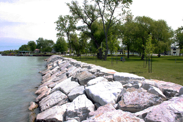
Mission Park, City of Sarnia (2008 – 2010)
Mission Park is located near the Sarnia downtown just south of Seaway Centre. This project involved replacing failing steel sheet piles and broken concrete and asphalt with stepped armour stone and sloped rip rap. Funding for this project is provided by the City of Sarnia with support from the Great Lakes Sustainability Fund, Great Lakes Renewal Foundation, the Imperial Fund and the Canada-Ontario Agreement through the Ontario Ministry of the Environment.

Point Edward Erosion Control Project (1995 – 2006)
The final phase of the Point Edward Waterfront Shore Protection Project was undertaken in 2006. This 265-metre phase of the project continued the shore protection and public access for the Point Edward waterfront. When combined with the 270 metres of waterfront access provided by the Ontario Lottery and Gaming Casino, over 1 kilometre of shore line is now available to the public in Point Edward. The waterfront protection and public access project began in 1995. In addition to the protection completed on public lands, the Blue Water Bridge Authority and the Lambton Area Water Supply System financed the protection work on their properties. The stepped and sloped armour stone provides natural and durable shore protection. A walking trail connects the Waterfront Park to the Casino and a network of trails around the entire Village leading into the City of Sarnia and to Canatara Park. The final phase of the project was funded by the Village of Point Edward and the Province of Ontario.

St. Clair River Shoreline Inventory (2004)
Through a $60,000 grant from the federal Great Lakes Sustainability Fund, the St. Clair Region Conservation Authority inventoried the Canadian side of the St. Clair River shoreline to document the condition of shore protection and to identify opportunities for shoreline habitat improvements. The inventory of the shoreline included properties from Point Edward to Port Lambton. The information collected provides the background the Conservation Authority needs to seek grants to support landowners in providing for cost-effective, environmentally-friendly shore protection.

Wallaceburg Erosion Control Project (2005)
The Conservation Authority supervised the rehabilitation of the fabriform erosion control structure along the south bank of the East Sydenham River in Wallaceburg. In several locations, gaps along the toe of the fabriform and voids under the fabriform were compromising the integrity of the structure. A local contractor was retained by the Conservation Authority to fill the voids under the fabriform with concrete grout and place large rock rip rap to protect the toe of the fabriform. This work was done to improve erosion protection of the bank and increase the longevity of the existing fabriform. The project was funded by the Municipality of Chatham-Kent and a Water Erosion Control Infrastructure grant. The total cost of the project was approximately $70,000.
St. Clair River Slope Stability Study (2001 – 2003)
The Township of St. Clair and the St. Clair Region Conservation Authority undertook a study of the slope instability in the Beresford Street area in St. Clair Township. The slope instability is threatening: Beresford Street; utilities such as sewers and hydro; and a number of residences. The study concluded the cause of the instability was the result of a deep seated circle slip failure. This instability is very difficult to correct.
Blue Point Cost Benefit Analysis (2002)
One of the most actively eroding Lake Huron shoreline reaches in our region is Blue Point in the municipality of Plympton-Wyoming. This area has also been a traditional area of development for cottages and homes. With increasing pressure to build on the remaining lots, the municipality requested the Authority coordinate a cost benefit analysis of providing erosion protection for the Blue Point shoreline. The report detailed the costs of shore protection to be in excess of $11 million, very close to the value of the properties to be protected.
Sarnia Erosion Control Project (1989 – Present)
Over the last two decades, over 2 km of shoreline in this area have been protected. The armour stone wall protects a roadway and utility corridor to permanent homes from wave and erosion danger. In addition, the project addressed recommendations from the city’s recreation master plan to provide safe access to the beach and to construct viewing platforms along the top of the bank. The majority of the protection was completed by 2001. Since that time, additional armour stone groynes and 150 metres of additional protection have been constructed as funds become available.

Sarnia Seawall (1978 – 1993)
In 1978 the City of Sarnia, the St. Clair Region Conservation Authority, the Province, and the St. Clair Parks Commission, with some assistance from the federal government, completed the first phase of the Sarnia Waterfront. The Authority constructed the seawall at a cost of $900,000 and the Parks Commission completed the landscaping behind the wall. Over the next decade, the City, Parks Commission, and the Ministry of Tourism and Recreation joined forces to complete 850 metres of shoreline at Centennial Park and the Sarnia Civic Showplace. The Park Seawall was the last portion of the wall to be completed and involved 170 metres of shoreline protection. The work was completed in 1993 at a cost of $400,000 with the costs shared between the Conservation Authority and the City of Sarnia with assistance from the Jobs Ontario Capital Grant Program.